Last weeks review: Changeable; very cool and wet Friday
Plenty of sunshine last Sunday afternoon with temperatures near average (Pershore 21.9c, Llanwnnen 19.3c) although cool for those typically exposed coasts (Aberdaron 15.6c). Some rain or showers about on Monday but falling in mostly small amounts, it was a warm, humid day for the Midlands (Wellesbourne, Warks 25.1c, Llanwnnen & Trawsgoed 20.3c). Limited sunny intervals with a lot of cloud on Tuesday with a scattering of mostly light showers, although parts of the Midlands did manage some better warm sunny spells (Pershore 24.4c), temperatures were up to average across SW Wales (Pembrey Sands 19.5c) but cool for NW Wales (Capel Curig max only 14.7c). Much of the Midlands and parts of West Wales (WW) stayed dry on Tuesday. Showers in places once more last Wednesday, some quite heavy over the Midlands, but as ever some spots escaped with a dry day (Coventry catching 6.8mm but less than 1mm at nearby Church Lawford). West Wales faring best with nice sunny spells afternoon (Aberporth 8.8 hours), and temperatures somewhat below average generally (Pershore 21.2c, Pembrey 19.6c).
Mostly dry and rather cool then on Thursday, best of the sunny intervals over the Midlands and south coast of Wales where some places managed to get close to the July average (Church Lawford 20.9c, Mumbles 18.8c), with just a few showers scattered about, mostly over SW and Mid Wales. Contrary to the model indications used in last weeks guide ("Friday may see a ridge and offers the best chance of pleasant dry weather") it was rather quite a shocker being very cool, dull and rather wet for most of us as a low tracked along the English Channel. Most places failed to top just 60f (15.6c) on Friday, the least cool being Milford Haven 16.2c and Nottingham 15.3c, while coolest places were Aberporth max 13.0c and Little Rissington 12.8c, temperatures more akin to October than High Summer these. It was the coolest July day for many years over the Midlands, at Coventry the 'high' of 13.6c made it the coolest high since July 1978 (12.8c). The rain tended to be persistent rather than heavy during Friday, the wettest spots Little Rissington (Cotswolds) 25mm and Whitechurch (Pembs) 23.8mm, Anglesey and the North Midlands though did stay on the northern most edge of the rainy zone getting very little. A bright and generally dry reprieve Saturday with pleasant sunny spells although temperatures were still rather below average (Pershore 21.5c, Mumbles 18.2c) and decidedly cool around Cardigan Bay (Aberporth max 14.8c).
The week ahead: Cool and unsettled but improving and drier from midweek
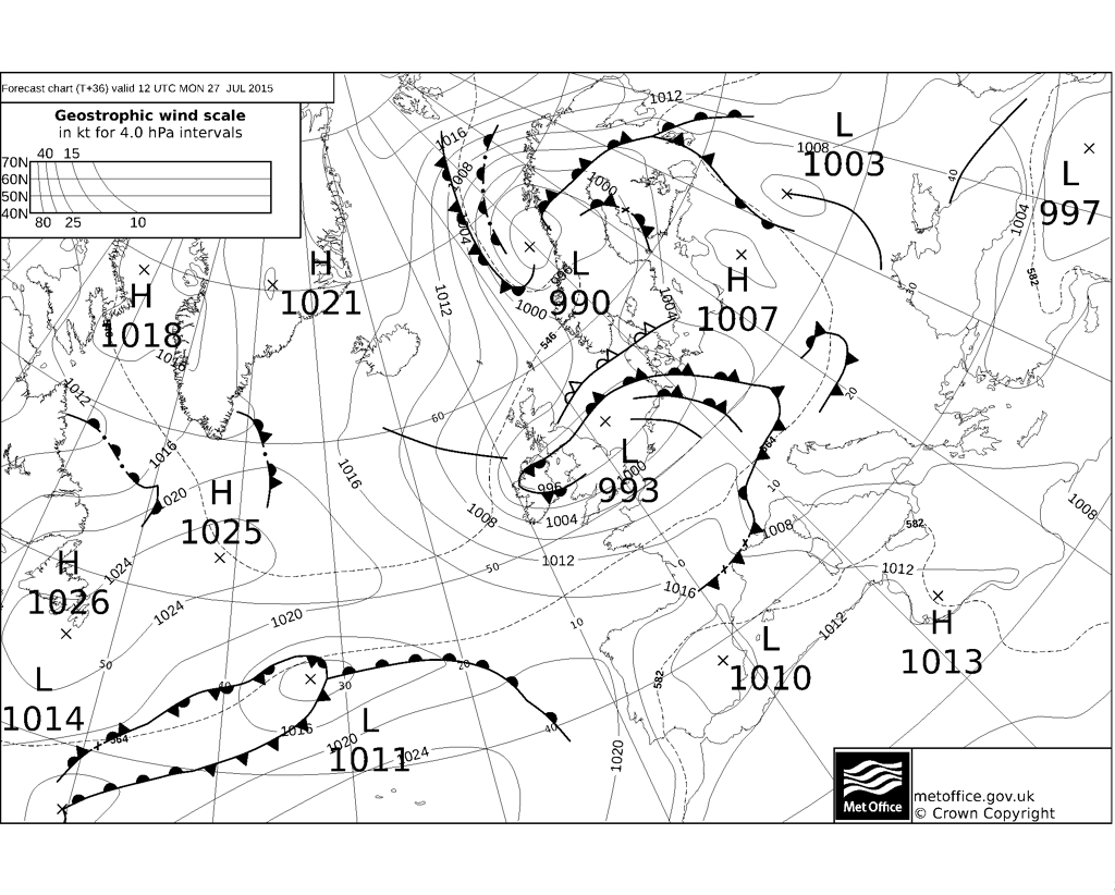
This mornings rain this has turned light and drizzly over WW and the SW Midlands and will clear the rest of the Midlands by the middle of Sunday afternoon. A rather windy afternoon of sunny intervals and showers, some heavy over Wales, maxima below average at 17 to 19c. Further blustery showers in places tonight, minima no lower than 11c. A rather deep Summer low is gradually crossing northern England during Monday so another disturbed day to come. Fresh to strong west winds driving through showers and some longer spells of rain, these heavy in places with the chance of a rumble of thunder. Few places expected to miss the showers on Monday and there will be some very heavy downpours for some, highs cool again at 16 to 19c (best East Midlands). The showers and strong winds set to continue in many areas throughout Monday night. Cool and showery again for Tuesday, although as the wind veers into the NW then SW Wales and the South Midlands are more sheltered with some places here escaping largely dry with sunny spells. Elsewhere though some heavy showers in places with more limited sunny intervals. Cool and quite windy, highs lucky to reach 14c over Snowdonia where showers may be frequent, 16 to 19c elsewhere. Most of the showers do die out overnight, clear spells and a decreasing wind lead to cool minima of 5 to 8c.
Cool yet again on Wednesday, bright sunny spells and scattered showers, a few of these being heavy and perhaps thundery, but more places will miss these and have a dry day. Highs just between 16 and 19c for most with a moderate NNW breeze. Wednesday night may be the coolest of the coming week, clear periods and light winds within a chilly air mass for Summer, coldest spots may even be close to a grass frost, with air minima as low as 3 to 5c, higher for towns and coasts. Hopeful that a ridge will give us a dry bright Thursday with decent sunny spells and with light winds feeling pleasant as highs increase to the 18 to 21c bracket, but cooler for some NW facing coasts (more like 16c here). Another cool and generally dry night follows possibly getting as low as 4c very locally. Its 'up in the air' from Friday really, although the signals are not suggesting great quantities of rain to end the week or into the weekend. Friday and Saturday then seems like (and bearing in mind how Friday gone turned out!) plenty of dry weather with perhaps the odd shower, temperatures higher and up to average at 19 to 23c, and there would be some pleasant sunny spells. However, this possible improvement does not look set to last as a nasty deep low could be heading towards Ireland come Sunday threatening further rain and strong winds to end the weekend!


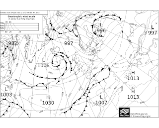


Mostly dry and rather cool then on Thursday, best of the sunny intervals over the Midlands and south coast of Wales where some places managed to get close to the July average (Church Lawford 20.9c, Mumbles 18.8c), with just a few showers scattered about, mostly over SW and Mid Wales. Contrary to the model indications used in last weeks guide ("Friday may see a ridge and offers the best chance of pleasant dry weather") it was rather quite a shocker being very cool, dull and rather wet for most of us as a low tracked along the English Channel. Most places failed to top just 60f (15.6c) on Friday, the least cool being Milford Haven 16.2c and Nottingham 15.3c, while coolest places were Aberporth max 13.0c and Little Rissington 12.8c, temperatures more akin to October than High Summer these. It was the coolest July day for many years over the Midlands, at Coventry the 'high' of 13.6c made it the coolest high since July 1978 (12.8c). The rain tended to be persistent rather than heavy during Friday, the wettest spots Little Rissington (Cotswolds) 25mm and Whitechurch (Pembs) 23.8mm, Anglesey and the North Midlands though did stay on the northern most edge of the rainy zone getting very little. A bright and generally dry reprieve Saturday with pleasant sunny spells although temperatures were still rather below average (Pershore 21.5c, Mumbles 18.2c) and decidedly cool around Cardigan Bay (Aberporth max 14.8c).
 |
| An unseasonably cool July day! http://www.met.rdg.ac.uk/~brugge/diary.html |
This mornings rain this has turned light and drizzly over WW and the SW Midlands and will clear the rest of the Midlands by the middle of Sunday afternoon. A rather windy afternoon of sunny intervals and showers, some heavy over Wales, maxima below average at 17 to 19c. Further blustery showers in places tonight, minima no lower than 11c. A rather deep Summer low is gradually crossing northern England during Monday so another disturbed day to come. Fresh to strong west winds driving through showers and some longer spells of rain, these heavy in places with the chance of a rumble of thunder. Few places expected to miss the showers on Monday and there will be some very heavy downpours for some, highs cool again at 16 to 19c (best East Midlands). The showers and strong winds set to continue in many areas throughout Monday night. Cool and showery again for Tuesday, although as the wind veers into the NW then SW Wales and the South Midlands are more sheltered with some places here escaping largely dry with sunny spells. Elsewhere though some heavy showers in places with more limited sunny intervals. Cool and quite windy, highs lucky to reach 14c over Snowdonia where showers may be frequent, 16 to 19c elsewhere. Most of the showers do die out overnight, clear spells and a decreasing wind lead to cool minima of 5 to 8c.
Cool yet again on Wednesday, bright sunny spells and scattered showers, a few of these being heavy and perhaps thundery, but more places will miss these and have a dry day. Highs just between 16 and 19c for most with a moderate NNW breeze. Wednesday night may be the coolest of the coming week, clear periods and light winds within a chilly air mass for Summer, coldest spots may even be close to a grass frost, with air minima as low as 3 to 5c, higher for towns and coasts. Hopeful that a ridge will give us a dry bright Thursday with decent sunny spells and with light winds feeling pleasant as highs increase to the 18 to 21c bracket, but cooler for some NW facing coasts (more like 16c here). Another cool and generally dry night follows possibly getting as low as 4c very locally. Its 'up in the air' from Friday really, although the signals are not suggesting great quantities of rain to end the week or into the weekend. Friday and Saturday then seems like (and bearing in mind how Friday gone turned out!) plenty of dry weather with perhaps the odd shower, temperatures higher and up to average at 19 to 23c, and there would be some pleasant sunny spells. However, this possible improvement does not look set to last as a nasty deep low could be heading towards Ireland come Sunday threatening further rain and strong winds to end the weekend!


No comments:
Post a Comment