Sunday 29 November 2015

Weather guide Monday 30th November to Sunday 6th December 2015

Last weeks review: dull and unsettled with occasional rain or showers; cold start then often mild.

Mostly dry with sunny intervals last Sunday, quite cold in many places but  some coastal parts of WW did attain average (Pembrey 9.7c, Shobdon 8.2c, Nottingham max 4.7c). Quite a sharp frost followed with temperatures widely below -2c with the -6.1c here at Llanwnnen colder than any official weather place in the UK (Tirabad, Powys -4.5c, Pershore -3.8c). Brightness for a time Monday but it clouded over with rain over NW Wales afternoon reaching other places during the evening. Cold over the Midlands (sub 7c max) but milder eventually for WW by evening (Valley 10.9c, Shawbury 6.8c). Temperatures continued to rise during Monday night reaching 12c over SW Wales with further rain for a time.

Tuesday was mostly cloudy with showery rain in places, this mostly affecting Mid & North Wales (Capel Curig 32.2mm) and also the NE half of the Midlands beyond Stafford & Leicester, with Pembrokeshire and the central & SW Midlands mostly dry, temperatures close to or a little above average (daytime highs Pembrey 10.5c, Hereford 10.4c). Quite mild and windy Tuesday night across Wales with further showers, heavy in places, drier and less breezy with clear breaks over the Midlands even permitting a ground frost at Pershore (air min 2.8c cf Pembrey 9.4c). Showery rain affected Mid and North Wales and the West Midlands Wednesday, the latter via a 'Cheshire Gap' streamer that squeezed showers between the hills of North Wales and the Pennines steering them in line SE across the Midlands, some places getting one after the other (Shawbury 9.2mm 24 hrs to 06z Thursday = wettest in UK). Quite mild in most places on Wednesday (Hereford 12.8c, Pembrey 12.3c) but another rather cloudy day.

Mild and mostly cloudy Thursday with a little rain or drizzle in places (Milford Haven 13.2c, Shobdon 12.8c), temperatures over parts of the Midlands suppressed to around average though (Church Lawford 9.5c). Mild and cloudy again Friday with an active cold front spreading rain and strong winds east during the afternoon and evening, heavy rain in places (Capel Curig 33mm). The front also brought a marked cool down as winds veered NW with a drop 3 or 4c in one hour (max before this Pershore College 12.8c, Pembrey 12.3c). Enough clear spells and wind drop to permit a widespread ground frost over the Midlands Friday night, most of WW too breezy for this though (air min Shobdon 0.3c, Llanwnnen 0.9c). Saturday started dry in places but unsettled again with showers and some longer spells of rain accompanied by strong winds. A cooler but far from cold day (Pembrey 11.6c, Pershore 10.4c, Nottingham max 7.2c).


The week ahead: unsettled and mostly mild, wet and windy at times; drier Friday into weekend

A very mild Saturday night, no lower than 10c along the south coast of Wales (min Milford Haven 10.7c). Windy on Sunday with severe gales for exposed places as winds gust above 70mph, courtesy of recently named storm Clodagh crossing northern UK.  A lot of cloud this afternoon with scattered rain or showers, heavy in places, very mild highs 11 to 13c, though perhaps a few late sunny intervals. Any remaining showers clearing this evening as it cools down to give a local ground frost in a few spots. However the next system brings cloud and rain after midnight and a wet windy dawn to Monday. Fronts then set to loiter all day across central Britain, so cloudy with spells of rain, Wales being particularly wet with many places ending up with a good inch while Capel Curig could get as much as 3 inches (75mm) taking its November total to around 800mm (31 inches)! Strong to gale force SW winds accompanying the wet weather as well during much of Monday but at least it will be academically very mild  at 12 to 14c.

Further spells of rain on Monday night again especially over Mid and North Wales as the fronts start to ease northwards drying it out over South Wales and the Midlands by dawn with just some residual drizzle. A very mild night temperatures in places remaining above an exceptional 12c and still quite windy. Tuesday sees a mild sweep of SW winds, mostly cloudy with occasional light rain or drizzle, a few bright intervals possible over the Midlands, very mild again highs 12 to 14c and rather windy. Another very mild night follows with further light rain or drizzle in places, no lower than 9c anywhere.  A cold front then edges SE during Wednesday bringing spells of rain and squally winds but it should reach 11 to 13c ahead of the front.

Fronts then look like stalling and even waving back over us during Wednesday night into Thursday which means further spells of wet weather to come (no doubt with flooding in places by this stage). It should be mild in most places still for a time Thursday (up to 13c over South Wales and the Midlands) but on the northern edge of the fronts much cooler air digs in, so perhaps only around 7c by afternoon for Snowdonia even with the risk of hill snow for a time before it clears. The clearance and colder air should then reach all places later on Thursday with some residual evening showers over WW and a much colder night with frost in places.

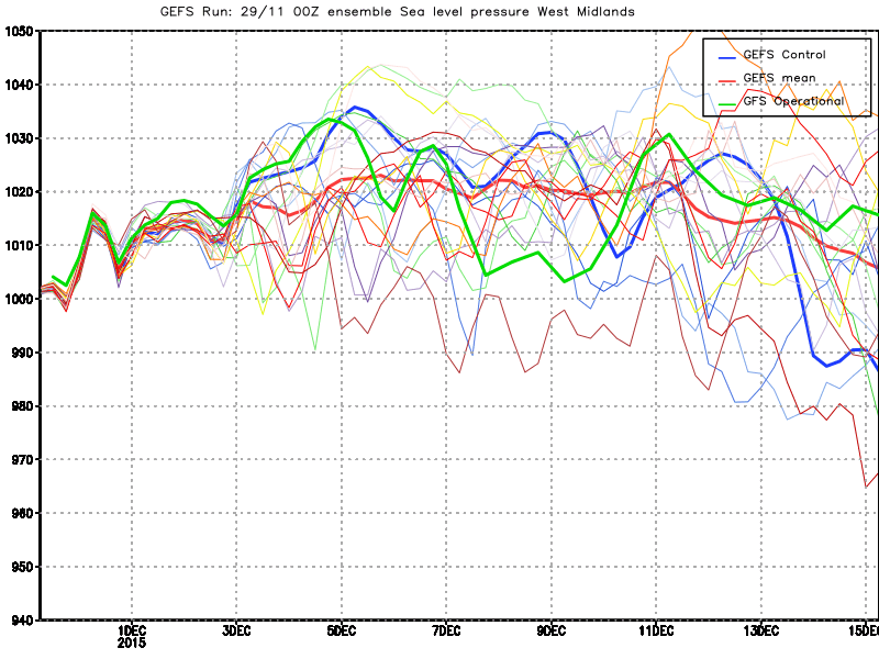
Model variations quite large come Friday, some having high pressure and dry conditions which could last into the weekend, others though keeping it unsettled although not as wet and windy as it will have been in the preceding days with pressure almost certainly somewhat raised by that stage and hence any fronts are weaker. Looking ahead to the middle of December and no sign of either prolonged cold or dry weather as the generally unsettled mild theme continues.


Sunday 22 November 2015

Weather guide Monday 23rd to Sunday 29th November 2015

Last weeks review: Mild and cloudy with rain at times; cold snap this weekend gave snow in places

Very mild indeed last Sunday, mostly overcast with a little rain or drizzle in places (Hereford 16.8c, Trawsgoed 15.3c). Rain crossed Wales during the evening but typically fizzled to almost nothing over the Midlands after midnight (Capel Curig 21mm overnight, Long Lawford a trace of rain for example). Strong to gale force winds especially for exposed parts of NW Wales Sunday night (Capel Curig gusts to 88mph). Brightness for a time Monday which was a less mild day (Pershore 12.8c, Mumbles & Pembrey 12.3c), rain spread to all areas late afternoon and evening, some of it heavy.

Some rain at times Tuesday which became very mild and very windy (Pershore 16.1c, Trawsgoed 15.0c).  The strongest winds were during the evening with severe gales in exposed places which experienced gusts over 70mph (Aberdaron 85mph) but with sustained gales also affecting parts of the Midlands (Shawbury max gust 66mph). Named 'Storm Barney' did then cause some damage and disruption to power supplies but this was not widespread. Wednesday and further rain or showers at times accompanied by strong winds but again a mild or very mild day (Hereford 14.3c, Mumbles 14.1c). Some torrential downpours about on Wednesday afternoon, the rain briefly falling at a rate of 129mm an hour here at Llanwnnen, while there was an 8mm in one hour downpour at Church Lawford, whereas other places saw very little rain (Shawbury, Salop 1.0mm day total).

Further rain for a time on Thursday for many places but much of it died out through the afternoon with only very small amounts for most of the Midlands in any case.  Cooler with a lot of cloud yet again, maxima in many places being during the previous night or early morning (Mumbles 12.4c, Pershore 11.4c). Cooler than for some time Thursday night although temperartures were above average minima in most places (Pembrey min 8.3c, Shawbury 3.1c). At last some sunny intervals Friday and just a few passing showers, colder but temperatures still close to the mid to late November average (Mumbles 10.2c, Hereford 9.7c) even though it felt colder with the wind! Showers turned wintry especially over hills during Friday evening.

Wintry showers on Friday night, with more prolonged outbreaks in places giving temporary coverings of snow in parts even to low levels. Lying snow if only a cm or 2 affected such places as Coventry, Solihull, the Brecon Beacons and Cotswolds, with up to 5cm reported in places above 1000 feet. Frost occurred where cloud breaks and wind permitted (Sennybridge min -0.8c). Saturday was a cold day for November, mostly dry and sunny across the Midlands but further wintry showers affected West Wales, we had a spell of wet snow here at Llanwnnen mid afternoon depositing a layer of slush on the lawn (Milford Haven 7.2c, Hereford 5.4c, Little Rissington max 3.1c).  The first widespread air frost of the month Saturday night (Church Lawford -2.2c)


The week ahead: unsettled, rain or showers and strong winds at times; fluctuating temperatures

As befits the month November is turning out rather wet and in spite of our cold snap will still end up a very mild month. More unsettled weather to come for the remainder of the month, showers or longer spells of rain and a with a little snow possible during colder incursions over hills as temperatures fluctuate. Sunday afternoon is bright and mostly dry apart from a drape of showers still over parts of West Wales that are tending to die down. Rather cold this afternoon, highs 6 to 8c but at least the winds are light. With a ridge over us tonight it will be mostly clear and frosty with fog in places, temperatures widely down to -2c inland and locally -4c.

Rather cold again Monday, dry and bright with sunny intervals for the Midlands but WW clouds over with a band of rain moving down from the NW later in the day, highs 6 to 8c, perhaps 9c Pembrokeshire. The rain should reach the Midlands during the late evening too. Spells of rain then for Monday night, some heavy, fresh to strong winds accompanying the rain, but temperatures hold up. Tuesday is bright and quite cool, fresh NW winds bringing showers of rain and hail and which could be wintry for highest ground, maxima 7 to 9c. A frontal feature could bring more prolonged spells of rain across Wales in particular during Tuesday evening into the night.

The NW flow keeps up for Wednesday bringing further showers but also with sunny intervals, most of the showers should be over Wales where they form streamers, with the Midlands tending to stay mostly dry and bright, highs again 7 to 9c, possibly 10c Pembrokeshire. A ridge then topples down across Wales and England Wednesday night into Thursday killing off most of the showers so it should become a largely dry night with ground frost possible for the Midlands. Milder westerlies arrive during Thursday, some sunny intervals for the Midlands but it becomes mostly cloudy with rain or drizzle in places, mostly over Wales, highs 9 to 11c and breezy. Mild and breezy with rain in places Thursday night no lower than 7c.

Friday looks like seeing active fronts crossing the UK bringing periods of rain, heavy at times accompanied by strong to gale force winds. There will be a transient warm sector raising temperatures to a mild 11 or 12c at some stage on Friday (probably morning) but the cold front sweeping through (probably afternoon) will bring a marked cool down. Showers, wintry over hills, arriving by Friday evening, especially for WW where hail may well be a feature. Next weekend looks like continuing unsettled with showers or longer spells of rain and perhaps wintriness for high ground at times as the air looks rather cold especially for Saturday, it will often be windy as well with gale risks. Frost though is unlikely due to all the cloud, wind and precipitation.


Sunday 15 November 2015

Weather guide Monday 16th to Sunday 22nd November 2015

Last weeks review: Often very mild, cloudy and quite windy with rain at times (mainly Wales) but a cooler, showery Friday

Much of last week was very mild and cloudy, record breakingingly mild for November overnight Monday as temperatures over parts of the UK did not fall lower than 16c which would be a warm July night! Hereford was the mildest place that night in our regions (min 14.5c) but many places remained above 13c. Up until Thursday WW saw occasional rain and drizzle, very little though within the 'rain shadow' of the Midlands which was mostly dry but quite cloudy. Snowdonia really sponged up the moisture as Capel Curig received 110.6mm (over 4 inches) in the 24 hours to Tuesday morning - 90mm of which falling in just 12 hours on Monday and after which the rain gauge seems to have developed a fault and so the total for the week is not known although it must be well over 200mm! The Midlands had the highest temperature readings last week peaking Tuesday at Newport (Salop) at 17.5c (7c above normal).

A measure of the exceptional mildess of this November to date is that many parts of the Midlands had maxima above 14c from the 4th to 12th and that nowhere across our regions has had an air frost (min below 0c) as yet, and some not even a ground frost. Friday was then the first day of the month to register below average temperatures in some places as most only reached 9 to 11c (Milford Haven 11.3c, Pershore 10.8c, Capel Curig max 7.8c) it was windy with showers in many places. Wet in many places yesterday (Saturday) with parts of WW getting quite large totals. A mild and rather windy day although it was late afternoon before the mild air reached the East Midlands. Temperatures peaked Saturday evening (Hereford 16.2c, Trawsgoed 14.9c) with an exceptionally mild night following (Hereford min 14.8c).


The coming week: Often mild with spells of rain and wind; colder more showery from Friday (some wintry)

Further heavy rain for Snowdonia on Saturday night, Capel Curig having had 62.8mm in the 24 hours to Sunday morning, elsewhere little or no rain has fallen in general. Capel Curig has had about 400mm (16 inches) in the past 11 days, so flooding is likely in North Wales this week. Mild for the most part but we may well be getting our first taste of Winter with a cold snap and even snow in places next weekend.

Very mild, mostly cloudy and windy this Sunday afternoon (gusts above 60mph last night over NW Wales) - mainly dry for much of the Midlands but some rain and drizzle at times across Wales, and again further heavy falls which may result in flooding for North Wales. A few bright or sunny intervals possible over the Midlands where temperatures could reach an exceptionally mild 17c locally, with it generally a very mild day at 14 to 16c. A more general band of rain overnight on a cold front, although again this should be mostly light for the Midlands, and clearing from all parts by around dawn. A cool down behind the front, as low as 5c in places but holding above 10c for the SE Midlands.

A semblance of a ridge Monday, sunny intervals with the outside chance of a light shower and less windy. Maxima Monday 12c for the Midlands and 9 to 11c WW.  The next lot of fronts bringing rain and increased winds to WW during the evening which soon spreads east into the Midlands overnight raising temperatures into double figures again after midnight. A low then crosses the UK during Tuesday so spells of rain, heavy in places and there could also be strong to gale force winds associated with this feature. Very mild in spite of the wind and rain, highs 13 to 16c. The worst of the rain should be clearing through Tuesday evening leaving a scattering of showers overnight, strong winds likely to keep up with gales for some.

Any ridging very transient early Wednesday as further lows and their fronts move in from off the Atlantic. Wales and England will come within a broad moist warm sector during the day, this once more having the potential to produce copious rainfall over the hills of Wales, so expect further large totals for the Capel Curig environs and to be hearing of flooding for parts of Wales midweek. Some rain may also affect the Midlands, more especially later in the day after some mild, brighter intervals here. Highs Wednesday very mild at 13 to 15c but it will end up another windy day as the SW wind increases. Fronts may then become slow moving across our regions during Wednesday night and so exacerbating any flooding, temperatures holding up above  a very mild 10c for most.

The latest GFS model output is concerning from a rainfall/ flooding perspective as it maintains active fronts across Wales and the Midlands during Thursday with a thoroughly wet day in prospect should this come to fruition. Not all models suggest such a wet day however, as some have the rain more intermittent and showery in nature, but in any case another mild day is likely, highs 11 to 14c, but strong winds for many areas once more, with a risk of gales at least for a time. A big cool down is underway by Thursday night as a cold front moves down from the north clearing the rain to more showery conditions.

Quite a potent late Autumn cold snap is being shown for the weekend and will be a shock to the system after a thus far exceptionally mild November! Fresh to strong northerly winds as the UK is set to lie between low pressure to our east and high pressure to our west. Friday appears to be the transitional day to this colder weather, a day of sunny intervals, cool NW winds and showers, some heavy with hail, and which may turn wintry over high ground by evening.  Maxima Friday 8 to 11c.

Saturday then looks a cold and potentially wintry day with a northerly blast bringing showers or longer spells of rain, hail, sleet and even snow. Lying snow though should be restricted to hills above 1000 feet, although virtually anywhere could see their first snow shower of the season during Saturday. Maxima a cold 3 to 6c feeling raw in the north wind and a total contrast to what we will be experiencing for much of this coming week and with frost likely overnight! Still cold with some wintry showers in places Sunday but suggestions of a ridge that would tend to kill most of these off.


Sunday 8 November 2015

Weather guide Sunday 8th to Saturday 14th November

Last weeks review: Record breaking warmth West Wales at first but foggy Midlands; then mild or very mild with some rain at times

Very mild last Saturday for Halloween, most of us seeing some sunny spells (Pershore 17.7c, Trawsgoed 17.3c). Fog in many places on Saturday night which lingered in some areas. A record breaking day ensued over Ceredigion and some other parts of WW where Trawsgoed had an incredible maximum of 22.4c - the warmest November temperature recorded in November in the UK. This beat the previous November record of 21.7c recorded at Prestatyn, North Wales way back in 1946. Many parts of WW topped 19c Sunday: Gogerddan 21.5c, Whitechurch 21.0c, Swyddfynnon 20.9c and Llanwnnen 19.9c! Very mild indeed elsewhere if the sun came out as many places topped 16c, however for others nearby the fog stuck much of the day, particularly along the river valleys of the SW Midlands. Driving from Coventry back to Wales on Sunday afternoon the warm sunshine was replaced by mist and fog along the Worcestershire M5 and M50 and west into the Brecon Beacons restricting temperatures to just 12 or 13c here (Midlands: Coleshill 17.8c, Hereford max 11.9c).

New Nov high temp record!


Clear spells Sunday night with fog widespread, this dense over parts of the Midlands on Monday morning. The fog then persisted over most of the Midlands and mid Wales for much of Monday, while WW saw Summer-like temperatures and sunshine for the second day.. in November! Remarkable temperature contrasts, Trawsgoed again 'hotspot' at 22.3c, claiming the record for the warmest ever UK temperature so late in the year! Gogerddan and Swyddfynnon both topped 21c with Llanwnnen not far behind on 19.2c, while Capel Curig in Snowdonia reached 18.9c and Aberporth on the coast 18.4c on a glorious late Autumn Monday across WW. Just 30 miles or so from Ceredigion Sennybridge only managed max 8.8c in the fog, much of the Midlands was foggy and cool as well at 8 to 10c max (Nottingham 8.2c), excepting for hills above the fog layer (Pennerley, Shropshire 16.8c).

Remarkable contrasts Monday Nov 2nd

Clear skies gave a ground frost over parts of WW Monday night (Llanwnnen air min 1.2c) while the fog/ cloud kept tempteratures up only slightly below their daytime levels across the Midlands (Nottingham min 7.2c). Some sun for WW for a time, but a lot of cloud Tuesday with occasional rain spreading north afternoon into the evening, temperatures down closer to average over WW but UP closer to average for the Midlands (Porthmadog 13.8c, Pershore 11.0c, Nottingham max 9.2c). Most of the rain died out during Tuesday night although still affecting the East Midlands by morning and a mild night (most staying above 8c). Bits and pieces of light rain and drizzle Wednesday but a generally dry day if rather cloudy and mild (Trawsgoed 15.7c, Hereford 15.2c).

Very mild across South Wales Wednesday night (Mumbles min 12.7c) then a mostly cloudy day with rain spreading east through the day, some quite heavy over WW although most of it cleared readily afternoon. Another mild if breezy and overcast day (Gogerddan 15.7c, Pershore 15.4c). Very mild air indeed returned for the end of the week as deep fetch SW winds arrived. Thursday night and most places remained above 11c which is where it should be on a November afternoon (Pembrey & Pershore min 12.6c). Rain for WW for a time Friday, with intermittent light rain also affecting the Midlands, a few brighter intervals made it very mild indeed in places (Hereford 17.6c) although all areas were very mild (Trawsgoed 16.3c, Capel Curig 14.3c).

Very mild Friday night and it became wet and windy over WW and much of the Midlands before dawn. Rain cleared WW Saturday morning after totalling an inch in places, with almost 2 inches for parts of Snowdonia (Capel Curig 46mm 24 hours to 1200) to a few showers, the Midlands too dried out afternoon with some sunny intervals. Very mild especially over the Midlands (Pershore 17.4c, Trawsgoed 15.7c).


October 2015 review: Most places  rather dry with temperatures near average

Most places had a dry October, a few very dry, while the odd spot did just about exceed average. Temperatures a touch above average in most places with sunshine below average over the Midlands while parts of WW were fairly sunny (an estimated 107 hours 117% here at Llanwnnen).

Some rainfall totalls:

Valley 58.2mm 58%
Trawsgoed 89.0mm 61%
Llanwnnen 71.1mm 50%
Aberporth 75.2mm 67%
Mumbles 58.4mm 47%

Nottingham 75.2mm 106%
Coleshill 56.4mm 77%
Coventry 63.8mm 94%
Church Lawford c. 59mm 105%
Long Lawford 47.8mm 87%
Hereford 35.8mm 46%
Little Rissington 58.0mm 70%


The week ahead: Often very mild and unsettled with spells of rain and wind; cooler Friday into Saturday

Clear spells enough to permit a touch of ground frost over Herefordshire on Saturday night (Shobdon air min 2.2c), in contrast over South Wales it was cloudy and mild (Milford Haven min 11.9c). Some rain in many places late in the night into this Sunday morning accompanied by strengthening southerly winds. More wet and windy weather this afternoon especially over WW as a low tracks close to NW Scotland, some heavy rain in places with winds gusting to gale force especially for exposed parts of Wales. Much of the Midlands may well miss the worst of the rain and stay largely dry until later afternoon or this evening. Very mild again today with highs between 14 and 16c.

The cold front should clear the rain east during the evening. So a dry calmer interlude for Sunday night. Very mild strong deep fetch WSW winds arrive during Monday bringing further fronts which may get strung out across central and northern UK. Worst of the rain and wind over north and west Wales and perhaps the north Midlands, some large totals adding up over the hills especially Snowdonia, while wind gusts could top 60mph in exposed places. Maxima Monday 13 to 16c, highest over the South Midlands where the odd bright chink may occur. Still some rain and drizzle in places Monday night which is rather windy but exceptionally mild, many places not falling lower than 13 or 14c!

Even more fronts for Tuesday so further spells of rain, some heavy over WW, while the Midlands should see some drier brighter intervals. Very mild again as temperatures widely reach 14 to 16c, even 17c possible for parts of the Midlands. With the slow moving fronts and orographic enhancement some very large rainfall totals may well have totted up come midweek over high ground, Capel Curig for example could get over 150mm (6 inches) in the coming 72 hours ahead to Wednesday afternoon. Even come Wednesday rain fronts and even a  wave depression could still be affecting southern UK and increasing these totals! In contrast much of the Midlands may see relatively small amounts of rain during this period. Mild once more Wednesday and it should be less windy.

Thursday and we may be in less mild air but should see a brighter drier interlude with only a few showers and maxima 11 to 14c. However the next Atlantic low and its rain fronts look set to move across Wales and western England later in the day. The transition to cooler weather continues at the end of the week, Friday looks unsettled with showers or longer spells of rain, hail in places, and a fresh to strong west to NW wind, highs only 8 to 11c at this stage, rather below average for mid November, although Snowdonia with plentiful showers may only reach a cool 7c. A transient ridge giving a drier spell by next Friday night (could permit slight frost) into Saturday but further rain and wind looks set to arrive later in the weekend.