Sunday 27 September 2015

Weather guide Monday 28th September to Sunday 4th October 2015

Last weeks review: Rather cool and changeable; dry and sunny  from Friday with  ground frost

Last Sunday was cloudy and quite cool for most of WW, while there was some sunshine for the Midlands (mainly East) with temperatures nearer normal (Winterbourne, B'ham 17.9c, Valley 16.9c, Capel Curig 13.2c). Mild on Sunday night, rain at times for West Wales (WW) in particular (Llanwnnen 13.4mm), this lasting into Monday morning and progressing across the Midlands but cleared most parts by the end of the afternoon to sunny intervals. Maximum temperatures by day were rather cool to average (Hereford 17.6c, Milford Haven 16.4c, Swyddffynnon 14.2c).

Heavy showers and longer spells of rain during Monday night affected WW and parts of the South and West Midlands. Further heavy showers about during Tuesday, North Wales and Ceredigion caught successive downpours energised by and streaming off adjacent relatively warm seas.  Here at Llanwnnen 9mm fell in just one hour just before dawn Tuesday with a total 25mm in the 24 hours to 1800, while Swyddfynnon 15 miles to our NE was the wettest place in the UK receiving 29.2mm. A few of the more scattered showers over the East Midlands produced thunder in the afternoon. A cool and breezy day everywhere, most places not managing 16c (Pershore 17.2c, Capel Curig 12.4c).

A bright start to Wednesday for WW gave way to light rain or drizzle in the afternoon, some of which moved to the Midlands by evening after a fairly bright day here. Rather cool to average temperatures (Hereford 17.7c, Valley 16.3c). Just the odd passing shower Thursday which was a mostly  dry day with sunny spells and marked the end of the rather unsettled spell as pressure began to build. Temps rather cool to average once more (Coleshill & Hereford 17.1c, Llanwnnen, Milford Haven & Valley 16.0c, Capel Curig 13.2c).

Friday was a pleasant day with sunny spells temperatures around the late September average in most places (Pershore 18.1c, Milford Haven 17.8c, Aberporth 14.6c). Clear and cold Friday night with a widespread ground frost, the Season's first air frost here at Llanwnnen as it dropped to -0.4c before dawn. Some other low readings: Tirabad, Powys +0.1c, Capel Curig 1.0c, Trawsgoed 1.3c, Pembrey Sands 1.4c, Shobdon 0.6c. Saturday a lovely sunny and rather warm day with Ceredigion one of the warmest parts of the UK (Gogerddan 19.1c, Llanwnnen 19.0c, Trawsgoed 18.8c, Nottingham 17.9c, Aberdaron & Little Rissington 15.9c).

The week ahead: Dry and quite warm with sunny spells, particularly West Wales, often breezy; showers possible weekend

The cool and changeable September is redeeming itself with plentiful warm sunshine this weekend, with dry, mostly fine weather lasting through into the beginning of October it would seem, although the Midlands in particular may be seeing more in the way of cloud at times from midweek as the wind turns more to ENE. Another fairly widespread ground frost last night (Shobdon +0.5c, Llanwnnen  +0.6c), mist and fog in places too. Sunny again on Sunday, and it soon warm up, highs again of 16 to 19c this afternoon with a gentle SE breeze. Clear and rather cold again tonight, ground frost probably less of an issue and with any fog patches restricted to the Midlands, lows generally 3 to 6c.

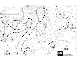
The large anticyclone that will dominate our weather this week is over the North Sea on Monday with a central pressure of 1040mbar. Another dry and mostly sunny day, temperatures perhaps slightly higher at 17 to 20c, more of a breeze especially for SW Wales though. The breeze prevents frost and fog Monday night even though skies remains clear, no lower than 4c anywhere. The ESE breeze quite fresh during Tuesday, however another largely warm and sunny day, just the chance of some areas of cloud affecting the Midlands, highs 16 to 19c, best over SW Wales. Again too much breeze for frost or fog Tuesday night.

Pressure still high midweek at above 1030mbar across the UK, being centred near Scotland but with quite a squeeze in the isobars to its south over southern England and Wales. A pronounced and cooler east wind for Wednesday then, still plenty of rather warm sunshine expected for WW, but the Midlands may well see quite a lot of cloud and be feeling cool in  the wind. Maxima Wednesday ranging from 18c for Pembrokeshire to 14c for more cloudy parts of the Midlands. Similar for Thursday too, although the east wind may have eased and the Midlands may also be faring better again for sunny spells, highs 15 to 17c and so a little above the 1st October average.

Still high pressure dominates come Fridaylying across or close to northern UK, however the air might be cooler with a keen east to NE breeze feeding in areas of cloud and the odd light shower from the North Sea. Sunny spells most likely for Cardigan Bay on Friday, while parts of the Midlands has a rather cool cloudy day, highs in the 12 to 15c bracket but a long way out to know for sure and it could turn out a rather more pleasant day than this guide anticipates. Still no frost or frost risk in the latter part of the week due to the breeze and patchy cloud cover.

Pressure does decline over next weekend so we may be seeing a few showers about, however there is still relatively high pressure close to northern Britain and on the whole it looks to be a  mostly dry picture. A proportion of the model output does though bring in a shallow low from France with attendant showery rain for a time, but this scenario is largely unsupported and the predominantly dry weather should prevail with at least sunny intervals and just the outside chance of a shower. Maximum temperatures for the weekend expected  between 13 and 17c, around average for the start of October.


Sunday 20 September 2015

Weather guide Monday 21st to Sunday 27th September 2015

Last weeks review: Rather cool and unsettled but became mostly dry

Mostly dry and bright last Sunday, Ceredigion doing best for temperatures which were a touch above the September average here (Gogerddan 19.2c), elsewhere temperatures near or slightly below average (Nottingham 18.4c, Aberdaron 16.9c, Little Rissington 15.8c). Mostly cloudy and showery Monday, some heavy and thundery showers over the Midlands and weak tornadoes were reported from various places including Tewkesbury, Leamington Spa and near Northampton.  South Wales saw longer periods of rain during Monday (wettest Milford Haven 55.2mm). A cool day in most places only Llanwnnen (17.8c) reaching average (Wellesbourne 17.2c, Mumbles 16.6c, Shobdon max 12.9c, Capel Curig 11.8c).

A lot of cloud with showers in places Tuesday, these less widespread than on Monday but still some heavy downpours in places, such as Coventry during the early evening (13mm). Rather cool for most (Pershore 18.4c, Milford Haven 17.5c, Shawbury 16.9c, Tirabad, Powys 14.0c). A chilly night for WW followed with a ground frost for parts of the NW (Capel Curig air min +0.9c). The deep low that was anticipated in last weeks guide to give us a wet and windy Wednesday merely side swiped us in actuality. The rain missed most of Wales and the NW Midlands which had a dry day with sunny intervals, but it did turn wet later in the afternoon into the evening across the south and east Midlands, with the edge through Coventry and Leicester. On the cool side almost everwhere again (Porthmadog 18.3c, Pershore 16.8c) and especially cool for mid Wales (Tirabad max 12.6c).

Sunny intervals and a few showers on Thursday, South Wales catching most of them with some heavy, temperatures average to rather cool (Pershore 18.7c, Mumbles 17.9c, Capel Curig 14.5c). Heavy downpours over parts of WW and the South Midlands during Thursday night (Aberdaron 22mm) then Friday mostly dry with sunny intervals and just the odd shower scattered about, a few heavy ones over the Marches in particular.  Temperatures just about exceeded the average in places (Church Lawford 19.3c, Mumbles 18.5c) while others were still quite cool (Aberporth 14.8c, Shawbury 17.1c).

A foggy start to Saturday in places, dense fog shrouded Draycote Reservoir near Rugby, in contrast to the sunshine in Coventry just 10 miles away (see below). At least some pleasantly warm sunshine for most places during Saturday, much of the the Midlands had a sunny afternoon and Anglesey had 10 hours sun (Newport, Salop 20.3c, Llanwnnen 19.7c,) but cooling sea breezes for Cardigan Bay coasts (Aberdaron 15.6c).

http://bablakeweather.co.uk/webcam.htm
Draycote webcam


The week ahead: Rather cool and changeable; fine, dry weekend

Thick fog over much of the Midlands this Sunday morning (even Coventry city centre), most of us seeing some sunshine this afternoon courtesy of a ridge, although WW may have a lot of cloud. Highs around 16c max WW and 18c Midlands, close to average for mid/ late September. Weather fronts bring patchy light rain and drizzle to WW eventually this evening. More organised rain overnight across Wales, possibly with some rather heavy bursts, this progressing into the West Midlands by dawn Monday, lows 10 to 12c. Monday then a rather cloudy and damp for the Midlands with some mostly light rain at times, the cold front clearing the rain from WW by lunchtime. Just a few showers affecting Wales during the afternoon with sunny intervals, it should be a bright end to the afternoon for most of the Midlands too. Highs rather cool at 14 to 16c.

A frontal disturbance moves across bringing showers and some longer spells of rain for Wales during Monday evening, heavy in places, this then onto the Midlands overnight, Sunny intervals and scattered showers on Tuesday, some heavy with thunder, these especially over the Midlands, highs 13 to 15c as the breeze turns into the north. Most of the showers dying out in the evening, lows 6 to 8c inland. Wednesday sees a transient weak ridge of high pressure quickly displaced by weak fronts so a mostly dry day with some sunshine over the Midlands, but it clouds over for WW with drizzle in places eventually, highs 15 to 17c. A little rain or drizzle in places then for Wednesday night which is quite mild remaining  above 10c.

Low pressure NW of Scotland on Thursday, we are in a rather cool WSW flow bringing some showers and sunny intervals. WW catching most of the showers where a few could be heavy, much of the Midlands on the other hand escapes largely dry and bright, maxima Thursday ranging from 13c for shower prone Snowdonia to 17c for brighter spots of the Midlands. Friday looks a rather cool and breezy day but bright with only a few showers expected.

Next weekend it is likely that high pressure will be over southern Britain, we should be seeing plenty of dry and rather warm Autumn weather with pleasant sunny spells, temperatures perhaps close to 21c 70f come Sunday.  The ECM model goes on to bring us a proper plume of warmth for the last couple of days of September which would see temperatures in the high 70's f (25c) should this scenario come to fruition. Fine and warm conditions may even hold into the beginning of October!


Sunday 13 September 2015

Weather guide Monday 14th to Sunday 20th September 2015

Last weeks review: Dry with some sunshine and warmth at times (especially Thursday), rain Friday night into Saturday

Most of West Wales was rather cloudy and cool last Sunday but with some sunny spells especially further south and well inland, the Midlands had a lovely sunny day with temperatures close to average (Pershore 19.9c, Mumbles 18.6c) - particularly cool for Cardigan Bay coasts (Aberporth max 14.2c). Many places had plenty of sunshine on Monday except it was cloudier for the East Midlands and Anglesey at times (Hereford 20.4c), a big contrast between the coast and inland  Ceredigion (Llanwnnen 18.9c, Aberporth 14.5c).

Chilly again Monday night with a touch of ground frost in a few spots (Pershore grass min -1c, Llanwnnen air min 1.4c). An east breeze around the high to our north gave big contrasts east to west on Tuesday, the Midlands very cool as cloud came off the North Sea while WW had almost unbroken sunshine and was rather warm (RAF Mona 21.0c, Little Rissington 15.4c, Nottingham 13.0c). Variable cloud with most places seeing some sunny spells Wednesday, although quite a lot of cloud for the Midlands in particular. Temperatures depended on amounts of sun but were generally close to or slightly below average (Pershore 18.2c, Capel Curig 15.4c) but rather warm for parts of WW (Llanwnnen 20.3c).

A lovely warm and rather sunny day virtually everywhere Thursday, many places getting above 20c (Coton-in-the-Elms, Notts 22.9c, Whitechurch, Pembs 22.1c, ). Friday then a breezy day, rather warm and quite sunny for the Midlands again, but more cloudy although rather warm for WW (Pershore, Mona & Valley all 21.9c).  A little rain in places Friday evening with a rather wet night for many, some heavy rain in places, especially Wales and parts of the West Midlands (Milford Haven 23mm). Some sunshine for Saturday afternoon with very few showers about, a cooler fresher day especially for Wales (Coleshill 19.5c, Llanwnnen 16.8c, Capel Curig 14.0c).

The week ahead: Cool and unsettled; wet and windy at times, drier and warmer next weekend

Sunny intervals and only a few scattered showers for most of Sunday, temperatures near average at 16 to 19c. Showery rain will be arriving this evening into South Wales with bits and pieces of rain possible anywhere during tonight. A low is slowly moving north across Wales and the Midlands during Monday, a lot of cloud tomorrow with showers or longer spells of rain, heavy in places, potential for localised flooding. A few sunny intervals too though, maxima cool at 14 to 17c, perhaps an 18c for brighter spots of the Midlands. Further showery rain in places for Monday night as well, although generally it becomes rather drier by dawn. The low is moving away into the North Sea during Tuesday, sunny intervals and scattered showers with a cool NW breeze, highs again 14 to 17c, even lower for shower prone Snowdonia (max 13c). Any showers dying out during the evening, clear periods and a chilly night, a ground frost possible, as low as 2c for North Wales and rural Shropshire.

The next low is in the SW approaches by Wednesday morning, some uncertainty as to the track and form of what may well be a deep and nasty low but it is likely to give many places a wet and windy day. It will be cloudy in most places by dawn Wednesday with rain edging north during the morning, some of this could be very heavy and accompanied by a fresh to strong east wind (with the low to our south). Further rain, very heavy in places through the afternoon. There could well be damaging gales associated with this low, at this stage Northern France and the Low Countries seem most likely to be affected, but this prognosis could change with parts of the UK coming into the firing line as well? Highs Wednesday rather cool with all the cloud and rain, once more being in the 14 to 17c bracket, cooler for the wetter areas though (max 13c).

The low will be crossing southern Britain during Wednesday night, further rain or showers in its circulation, but by this stage some areas will be drier, the wind dropping within the low itself (Midlands?) although peripheral areas (Irish Sea?) could be seeing strong to gale force WNW winds overnight. The low moves away NE across the Irish Sea during Thursday, a cool, windy and showery day, longer spells of rain possible too in places, highs just 13 to 17c. The worst of the wind and rain or showers should be over by Thursday night as things turn calmer and drier. Still some scattered showers about for Friday but better chances of escaping largely dry and bright and the wind is lighter, maxima a touch higher at 15 to 18c.

Next weekend may be somewhat changeable but much less disturbed than was the midweek period! Pressure will have undergone a substantial recovery by then and although there could be some fronts bringing some rain at times, a rather drier and warmer picture does seem likely.


Sunday 6 September 2015

Weather guide Monday 7th to Sunday 13th September 2015

Last weeks review: Cool or very cool and rather cloudy with showers and some longer spells of rain

Rather cloudy last Sunday with some rain in many places eventually, though amounts small everywhere, and much of NW Wales stayed dry. Temperatures close to or below normal (Porthmadog 19.2c, Nottingham 19.1c). Many places saw more appreciable rain during Sunday night, and for the Midlands it was a very cool, cloudy and rather wet Monday, almost an inch of rain in places (Shobdon 16.4c, Northampton just 14.0c, Market Bosworth 17.6mm rain). It was the coolest day of the whole Summer at Coventry (max 14.6c). Mostly dry though on Monday, bar a few showers, for West Wales and it brightened up here with temperatures closer to average (Pembrey 19.1c) and for NW Wales it was a sunny and reasonably warm day (Porthmadog 19.6c, Valley 12.3 hours).

Sunny intervals and some showers Tuesday, heavy with thunder in places, as ever quite a few places missed them, cool to average temperatures (Astwood Bank, Worc 20.0c, Mumbles 17.9c, Aberporth 15.0c). Torrential downpours and thunder over the Brum - Coventry areas during the evening (Coventry 17.8mm). Further showers in many places Wednesday too, Ceredigion and Snowdonia particularly prone to the showers, while more sheltered SW Wales and parts of the Midlands were largely dry with sunny intervals. Cool everywhere and particularly so for cloudy damp Ceredigion (Pershore 18.5c, Pembrey 17.0c, Swyddfynnon max 12.8c).

Very cool and breezy and rather cloudy Thursday but with showers fewer and lighter, and more places tending to stay dry. Many places failed to top just 60f 15.6c (Pershore 16.4c, Valley 16.0c, Capel Curig 13.2c), these figures 3 to 5c below the early September average. Only a few light showers left come Friday, but still that cool north to NW breeze (Pershore 18.5c, Mumbles 16.7c, Aberporth 13.7c). Some rain and drizzle Friday night/ Saturday morning (mostly Wales) but it became fine and bright eventually in most areas. Still cool and breezy although not too bad along the South Wales coast (Pembrey 18.1c, Pershore 16.6c, cloudier Little Rissington 14.0c). Cool on Saturday night close to freezing in places (Sennybridge/ Tirabad  1.5c, Llanwnnen 1.7c).

August review: Rather cool and cloudy, wet in places

The poorest aspect of August regards Summer weather was the lack of sunshine, as although we lacked a prolonged warm spell temperatures averaged out only slightly below average. Rainfall was quite variable as is typical of a Summer month, some places had a very wet month with almost twice the average (Shobon 190%) while others were marginally on the dry side (Capel Curig 97%).  Some rainfall totals:

Valley c. 80mm
Capel Curig 175.8mm 97%
Llanwnnen 108.5mm 100%
Aberporth 70.6mm 103%
Pembrey Sands 138.4mm 154%
Milford Haven 110.0mm 

Shobdon, Herefordshire 116.2mm 190%
Coventry, Bablake School 65.8mm 100%
Church Lawford, Warks 72.2mm 
Long Lawford c. 74.8mm 124%
Pershore c. 92mm 
Little Rissington 61.0mm 106%

Summer 2015 review: Rather cool and changeable

June was fine and dry if not so warm, while July and August proved disappointingly cool and cloudy. Hot spells were brief at best although the Midlands did see very hot weather into the low 90's f (above 32c) at the very start of July. Rainfall for Summer 2015 ranged from somewhat below to around average in most places, with only a few spots rather wet due to localised downpours (as at Pershore).

Summer rainfall totals:

Valley c. 167mm
Llanwnnen 258.0mm 92%
Pembrey Sands c. 244mm

Long Lawford 176.3mm 99%
Church Lawford c. 174mm
Coventry, Bablake school 176.0mm 102%
Pershore c. 190mm

The coming week: Dry with some sunshine and becoming warm; some rain eventually next weekend

High pressure gradually traverses the UK in the first part of this week on its journey to Western Russia via Scandinavia. A mostly dry week to come, warmer than the latter part of August and certainly feeling so after the cool start to September we have endured. However, as in usually the case with anticyclones cloud amounts difficult to ascertain, they will be variable and in places extensive, so that some days some areas fare well for sunshine while others are cloudy and cooler. Most of us should see at least a couple of fine warm Autumn days though this week with temperatures around 21c come the end of the week. The weather may well break down into a more unsettled pattern come next weekend, with some rain about by then.

The high is moving into Ireland today (Sunday) a dry afternoon with variable cloud and at least some sunny intervals for most, best of the sunshine for the SW Midlands and South Wales, more cloud affecting Irish Sea coasts, highs ranging from just 16c where it remains overcast to 20c where decent sunny spells occur, and at last that chill north wind has been cut off! Clear spells and a cool night to come, locally 2c again for the Marches and Mid Wales, there could be more cloud for the East Midlands where it would then remain above 9c. A similar day Monday of variable cloud, decent sunny spells in places but rather cloudy in others temperatures 16 to 20c, gentle breezes. Again a chilly night where cloud breaks permit, close to a ground frost very locally.

By Tuesday the high is leaving Scotland into the North Sea this having the affect of turning winds to the east which should benefit WW where the sun should make more of an appearance and it should warm up. Parts of the Midlands on the other hand rather cloudy perhaps? Temperatures again 16c where cloudy, 20c for more fortunate bright areas such as Pembrokeshire. A more definite SE breeze come Wednesday, a dry day again with better prospects for sunny spells in most places, and a warmer day, maxima generally 18 to 21c, perhaps the odd 22c. Nights are not so cool for the middle of the week with more of a breeze.

With the anticyclone over Scandinavia by Thursday we start to see Atlantic fronts encroaching towards SW UK. This may have the effect of tightening the isobars so that for Thursday and Friday it is quite windy, however the air is coming from well to the SE or south at this stage and it will be rather warm. Still perhaps areas of cloud about but most places would be expected to see pleasant sunny spells during Thursday and Friday and there is the potential for temperatures to exceed 21c widely and highest readings could be around 24c.

The weather looks like breaking down during next weekend, although Saturday could just about hold onto the dry, bright and warm conditions. However there may be some showery rain about especially across Wales Saturday, and a trough may well be giving us all some rain and lower temperatures come Sunday but that is a long way off..