The dry, sunny and rather warm spell managed to hold on for the whole week making it just about the most prolonged such spell of 2015! Last Sunday's warm spot across our regions being Whitechurch 19.4c and Coleshill 18.3c, both readings several degrees above the average for the end of September with virtually everywhere bettering 17c. Clear cool nights though at the start of last week even with ground frost over Worcestershire and the Marches Sunday night, air mins Shobdon 1.7c, Capel Curig 2.2c. Warm and sunny after the chilly start Monday (Porthmadog, Gwynedd 20.8c, Coton-the-Elms, nr Burton-upon-Trent, Derbyshire 19.6c). Similar on Tuesday although with the sun more hazy (Whitechurch 19.7c, Pershore 18.4c).
Pressure was notably high for September peaking at 1039mbar over East Midlands early in the week with the anticyclone centred over the North Sea. The high maintained its grip right through to the end of the week with more quite warm and sunny weather. Fairly sunny but breezy, quite windy even in places on Wednesday but temperatures above average again (Pembrey 18.8c, Pershore College 18.8c). On this the final day of the month Braemar in the Scottish Highlands recorded both the coldest (min -1.3c) and warmest (max 24.3c) temperatures in the whole of the UK not only for Wednesday but also for the whole of September!
Thursday was a splendid sunny day once any morning low cloud, mist or fog dispersed, temperatures warm indeed for the start of October especially for parts of WW (Mona 19.5c, Pershore College 18.6c). Fog and frost in places Thursday night (Capel Curig -1.1c), bright sunshine after any fog cleared Friday and rather warm for many places (getting above 16c qualifies for that now we are into October, Trawsgoed 18.6c, Shawbury 18.1c). Thick fog in places on Friday night, the sub 100m visibility here at Llanwnnen not being untypical and also with local frost (Swydffynnon coldest in UK min -0.4c). Any fog or cloud cleared to sunny intervals across WW while it stayed cloudy, misty and cool over much of the Midlands on Saturday (Mumbles 16.6c, Coleshill 12.2c).
September highlights
Pressure was notably high for September peaking at 1039mbar over East Midlands early in the week with the anticyclone centred over the North Sea. The high maintained its grip right through to the end of the week with more quite warm and sunny weather. Fairly sunny but breezy, quite windy even in places on Wednesday but temperatures above average again (Pembrey 18.8c, Pershore College 18.8c). On this the final day of the month Braemar in the Scottish Highlands recorded both the coldest (min -1.3c) and warmest (max 24.3c) temperatures in the whole of the UK not only for Wednesday but also for the whole of September!
Thursday was a splendid sunny day once any morning low cloud, mist or fog dispersed, temperatures warm indeed for the start of October especially for parts of WW (Mona 19.5c, Pershore College 18.6c). Fog and frost in places Thursday night (Capel Curig -1.1c), bright sunshine after any fog cleared Friday and rather warm for many places (getting above 16c qualifies for that now we are into October, Trawsgoed 18.6c, Shawbury 18.1c). Thick fog in places on Friday night, the sub 100m visibility here at Llanwnnen not being untypical and also with local frost (Swydffynnon coldest in UK min -0.4c). Any fog or cloud cleared to sunny intervals across WW while it stayed cloudy, misty and cool over much of the Midlands on Saturday (Mumbles 16.6c, Coleshill 12.2c).
 |
| Thick fog Saturday dawn |
September highlights
In spite of the rather warm sunny days at the end of the month, overall September was rather cool. Although for the most part a changeable month most places were fairly dry, just a few areas getting over the average. It was prevented from being slightly dull by all the sunshine in the final week with most places ending up having a rather sunny month as a consequence! The months high temperature at Coventry was just 20.8c the lowest such figure since September 1967.
Some September rainfall totals:
Valley 44.6mm 62%
Trawscoed 70.6mm 71%
Llanwnnen 93.9mm 87%
Aberporth 51.6mm 73%
Milford Haven 106.2mm 124%
Pembrey Sands 67.4mm 87%
Nottingham 25.4mm 42%
Coleshill 42.0mm 68%
Bablake School, Coventry 59.4mm 100%
Long Lawford, Rugby 44.5mm 82%
Church Lawford 55.6mm 85%
Hereford 31.8mm 63%
And sunshine:
Valley 187.6 hrs 143%
Llanwnnen (est) 158 hrs 127%
Aberporth 153.7 hrs 108%
Shawbury, Salop 150.2 hrs 128%
Coventry 159.5 hrs (sunniest since 2003)
The week ahead: Unsettled and mild at first, becoming mostly dry and bright if cooler
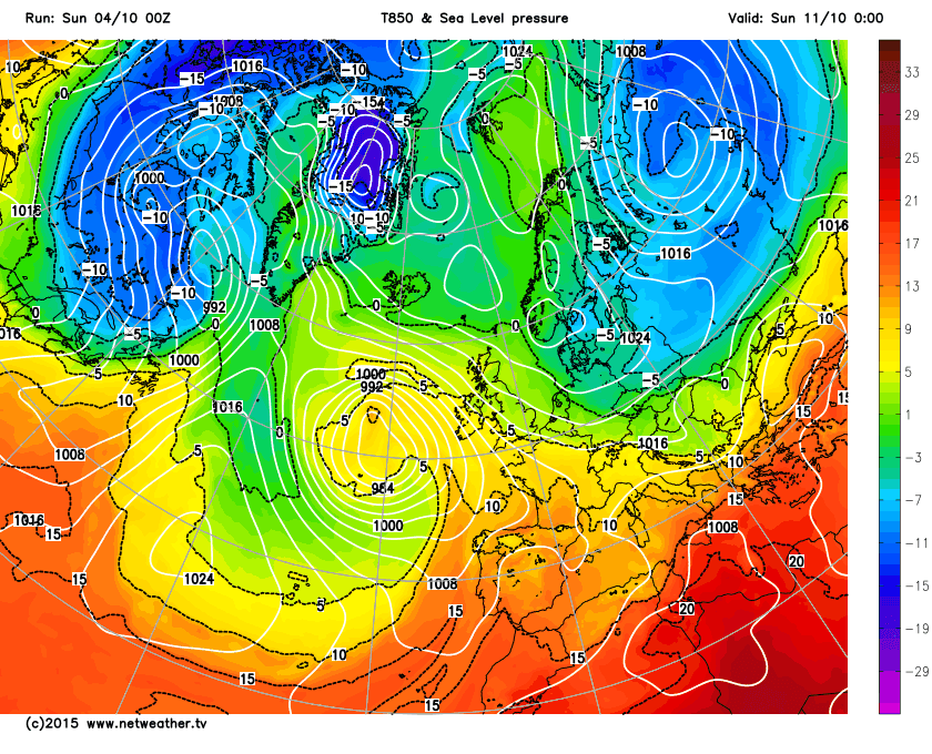
The fine spell is about to end with Sunday the last dry day (most places have a had well over a week of dry conditions). Less in the way of fog and frost this Sunday dawn (we had both briefly here at Llanwnnen), another dry day ahead with some sunshine and quite mild at 15 to 17c. A little low arrives into the SW overnight bringing a big change to rain and strong winds to most places, some of the rain heavy, especially across Wales, no lower than 10c. Monday is a rather warm unsettled day; early rain clears to sunny intervals and a few showers, with another rain band due later in the day. Warm humid air for Monday, temperatures generally 16 to 18c, the odd 20c possible over the Midlands where decent bright spells permit. A mild night with some shower follows, no lower than 11c.
Another low system crosses Wales during Tuesday bringing further showers and perhaps a longer spell of rain, some heavy with thunder chances. Mild and breezy highs of 15 to 17c. Showery rain lasting in places well into Tuesday night accompanied by fresh to strong NW winds for a time as the low moves away into the North Sea and bringing down cooler air. Still a few showers about for Wednesday but many places having a largely dry and bright day although cooler, maxima 12 to 14c with winds decreasing. Clear periods and quite cold Wednesday night with a widespread ground frost and fog in places by dawn.
A ridge of high pressure gives a nice dry day with sunny spells Thursday and light winds, highs average at 13 to 16c. Again frost and fog in places Thursday night as skies clear, lowest temperatures around 0c. What once was Hurricane Joaquin looks set to move towards Ireland by the end of the week, however it is prevented from bringing stormy weather to England and Wales by a blocking high over Scandinavia that should stall the deep low out to our west. Friday then looks quite a nice day again, dry for most, just the outside chance of a shower and milder at 15 to 17c.
Next weekend and ex-hurricane uncertainties aside, plenty of dry bright if breezy weather with a strong ridge into SE UK while pressure is low to our west. Still a chance that fronts do reach western UK so there is a chance of some rain and fresh winds for a time over the weekend for West Wales with the Midlands quite likely to have a completely dry weekend. Temperatures around average we shall suggest but dependent on wind direction, if there is an ESE feed off the Continent then feeling quite cool, but if it gets around more to the SSE then quite warm air would waft up (some uncertainties over this).


And sunshine:
Valley 187.6 hrs 143%
Llanwnnen (est) 158 hrs 127%
Aberporth 153.7 hrs 108%
Shawbury, Salop 150.2 hrs 128%
Coventry 159.5 hrs (sunniest since 2003)
The week ahead: Unsettled and mild at first, becoming mostly dry and bright if cooler
The fine spell is about to end with Sunday the last dry day (most places have a had well over a week of dry conditions). Less in the way of fog and frost this Sunday dawn (we had both briefly here at Llanwnnen), another dry day ahead with some sunshine and quite mild at 15 to 17c. A little low arrives into the SW overnight bringing a big change to rain and strong winds to most places, some of the rain heavy, especially across Wales, no lower than 10c. Monday is a rather warm unsettled day; early rain clears to sunny intervals and a few showers, with another rain band due later in the day. Warm humid air for Monday, temperatures generally 16 to 18c, the odd 20c possible over the Midlands where decent bright spells permit. A mild night with some shower follows, no lower than 11c.
Another low system crosses Wales during Tuesday bringing further showers and perhaps a longer spell of rain, some heavy with thunder chances. Mild and breezy highs of 15 to 17c. Showery rain lasting in places well into Tuesday night accompanied by fresh to strong NW winds for a time as the low moves away into the North Sea and bringing down cooler air. Still a few showers about for Wednesday but many places having a largely dry and bright day although cooler, maxima 12 to 14c with winds decreasing. Clear periods and quite cold Wednesday night with a widespread ground frost and fog in places by dawn.
A ridge of high pressure gives a nice dry day with sunny spells Thursday and light winds, highs average at 13 to 16c. Again frost and fog in places Thursday night as skies clear, lowest temperatures around 0c. What once was Hurricane Joaquin looks set to move towards Ireland by the end of the week, however it is prevented from bringing stormy weather to England and Wales by a blocking high over Scandinavia that should stall the deep low out to our west. Friday then looks quite a nice day again, dry for most, just the outside chance of a shower and milder at 15 to 17c.
Next weekend and ex-hurricane uncertainties aside, plenty of dry bright if breezy weather with a strong ridge into SE UK while pressure is low to our west. Still a chance that fronts do reach western UK so there is a chance of some rain and fresh winds for a time over the weekend for West Wales with the Midlands quite likely to have a completely dry weekend. Temperatures around average we shall suggest but dependent on wind direction, if there is an ESE feed off the Continent then feeling quite cool, but if it gets around more to the SSE then quite warm air would waft up (some uncertainties over this).


No comments:
Post a Comment